…in which the silent fading away of a once "conspicuous" line along parts of
the shore provides yet another line of evidence to support the theory of a
decline in overall marine productivity, of a general shrinking of the plankton food-base that
supports the entire web of marine life...
by Debbie MacKenzie October, 2001
"Where the midlittoral zone is most clearly developed, barnacles form a dense continuous sheet on the rock; in most places, the sheet has a rather sharp upper limit, which forms one of the most distinct landmarks on the shore. Individual barnacles straggle above this limit, but, while these are visible from a slight distance, the upper boundary of the main mass of the barnacles often forms a conspicuous line,
which may be visible miles away." - T. A. Stephenson (190? -1961)
The disappearance, over the span of the last half century, of the high bright white "barnacle belt" from exposed rocky shorelines provides a concrete visual indicator of the simultaneous decline in marine primary productivity. In Nova Scotia today, it appears that the only locations supporting barnacle growth heavy enough to form a "conspicuous line" that might be "visible miles away," is in heavily polluted harbours such as Halifax, Nova Scotia. In cleaner coastal marine habitat that white line appears now to have been erased.
A large amount of evidence today supports the theory that the total marine biomass has been significantly lowered due to the cumulative effects of human activity (largely fishing). Nutrient cycling in the sea continues to follow the patterns established long ago, and is still affected by a large number of physical, chemical and biological factors, but the ocean ecosystem today is operating at significantly reduced capacity - primarily because the overall volume of organic material and nutrients in the sea has become depleted. The cumulative impact of human removal of food from the sea has ultimately been felt throughout the whole system, and has had the effect of lowering the availability of food (specifically protein/nitrogen) to marine life in general.
Any worthwhile new theory suggests many testable hypotheses.
Therefore, a measurable decline is predicted to have already occurred in multiple unexploited marine life forms as well as in those species that have been specifically harvested by humans. The ubiquitous barnacle, a small, non-motile suspension feeder, has many features that make it an ideal ‘indicator organism’ for the nutritional value of seawater. Barnacles are directly limited in the upward expansion of their vertical range according to the high tide level, and also by the abundance of food contained in that tide.
‘Overall marine biomass depletion,’ resulting in a generalized decrease in the average food concentration in the seawater, would therefore predictably cause a downward contraction in the range of barnacles in areas exposed to the open ocean.
This expectation directly contradicts the effects predicted by ideas like ‘marine primary productivity is constant’ (which seems to predict either no change in food availability to barnacles, or possibly increased food) and ‘species replacement theory’ (which predicts increased food available in the system at lower trophic levels once the abundance of the higher ones has been significantly reduced). Also the idea that ‘the open ocean is affected by nitrogen/nutrient overload’ would seem to predict that barnacles today might be unusually well nourished.
However, objective evidence today appears to contradict these earlier expectations.
To test the hypothesis that a downward contraction in the vertical range of barnacles has occurred in tandem with the fisheries decline, and the (well documented) zooplankton decline, visual inspection was done at several areas of classic barnacle habitat in Nova Scotia. These specific sites were selected because scientific records exist of the barnacle populations that inhabited these same rocks over 50 years ago. These sites are also representative of ‘typical’ rocky intertidal zones in this part of the world. The main emphasis was placed on observation of the location of the upper vertical limits of barnacle growth. The rough abundance of barnacles was also noted. A remarkable decline was observed. This represents yet another reflection and demonstration of the clear declining trend in marine primary productivity in the North West Atlantic ocean.
Balanus balanoides was chosen as an indicator organism for the ‘nutritional value’ of seawater. Although a careful assessment of almost any marine organism would be expected to show the same trend, accurate historical data is the thing that is most often missing. This common barnacle that lives on the shoreline of Nova Scotia has natural characteristics that make it particularly well suited for use as a nutritional "biomonitor" or "indicator organism" and at least a few good historical records exist for this one.
What is an ‘indicator organism?’
An ‘indicator organism’ is one that reliably exhibits a measurable physical change in response to a change in its environment, therefore serving as a living monitoring device for the environmental change in question. Aquatic scientists’ interest in organisms as indicators of water quality has generally been along the line of thinking that the presence or absence of certain species in certain locations can be used to indicate degrees of water pollution (often nutrient pollution is the focus, but also possibly anthropogenic chemical pollution as well.)
Indicator organisms have generally been sought to show the presence of substances in the water that should not be there…and not usually organisms that give information regarding substances that are missing from the water. But indicator organisms could equally be expected to serve this purpose. The distribution of marine intertidal organisms can be studied to reveal information about the nutritional richness of their environment. The fact that many are permanently attached to rock, along with the reality that they can only feed during the time that they are covered with seawater, has the effect of turning the rocky intertidal zone into a steady gradient of reduced feeding opportunity the higher one goes. This is a well recognized feature of intertidal zones and the role that this increasing nutrient shortage (accompanied by the added stress of increased time exposed to air) plays in determining the vertical zonation of organisms has been well described in the literature. Changing abundances of organisms can be explained by many and various forces, but a gradual shift in the actual vertical position of an established intertidal zone would normally be expected to be only a function of sea level. Scientific writings on this topic seem based on the assumption that the average nutrient (food) content of oceanic seawater in a given part of the world is a constant feature. But IF it were not a constant - shifts in the vertical limits of some of the living organisms that make up intertidal zones would be an expected consequence of a shift in nutrient content of seawater.
This leads to the realization that barnacle distribution, especially the proximity of the upper vertical range limit to the extreme neap tide high water mark, serves as an ideal visual indicator of the abundance of plankton in the surrounding seawater. (Extreme neap tide high water mark is the approximate theoretical upper limit for barnacle growth, although it moves upward with degrees of wave exposure…the point that the author is trying to illustrate in this paper is only that the upper limit has shifted downward over time.)
A fascinating little creature, the barnacle has been described as spending its life attached head first to a rock and kicking food into its mouth with its feet…
Barnacles are consumers of phytoplankton and zooplankton both, but an adequate supply of zooplankton is undoubtedly important in maintaining adequately nourished barnacles. Direct measurements of the true abundance (or productivity) of organisms as transient and patchy in their distribution as phytoplankton, appears to be impossible with the data that is available on this topic today. But it is certain that the zooplankton are becoming increasingly diluted in oceanic seawater today. Zooplankton abundance on the Scotian Shelf (and elsewhere in the world ocean) has been undergoing a decline in recent decades (DFO Science SSR G3-02 (2000), IGBP, 1997).
The barnacle, due to several aspects of its nature, provides an excellent monitoring organism for assessing the nutritional content of seawater available to the whole range of marine plankton feeders. Barnacles are much easier to observe and measure than is plankton itself - the barnacle should provide an accurate proxy record, and its permanent attachment to solid intertidal features also offers an important advantage. The problems of timing the sampling ‘tow’ to accommodate the temporal and spatial patchiness of plankton occurrence…these problems are eliminated when sampling and observing barnacle populations instead. Individual barnacles live several years (3 - 5) therefore annual fluctuations in nutrient availability patterns will be ‘averaged’ by an organism like this. A ‘perennial’ organism records more information than does a shorter lived ‘annual.’ Barnacles appear to be fairly highly resistant to the effects of chemical pollution (witness their continued success in heavily polluted harbours such as Halifax). With their thick shells, they are also well equipped to resist the damaging effects of dessication, temperature extremes and ultraviolet radiation (Anderson, 1994). The constant and ubiquitous occurrence of barnacles in certain marine habitats, especially along rocky exposed shorelines, added to the fact that they consistently push the "upper limit" in their habitat, (the very highest positioned individuals are always flirting with starvation) - these features make this particular organism an ideal ‘biological indicator organism’ for the nutritional richness of the seawater. The existence of large, mature barnacle specimens, and their position within the vertical span of the intertidal zone provides a useful reflection of plankton/primary production levels in the surrounding seawater.
"The barnacle zone on rocky shores is the highest zone."
Statements to this effect are commonplace in modern textbooks and articles describing zonation patterns of life in cold temperate intertidal zones. But today's barnacles much more rarely live up to this expectation compared to several decades ago, when most of the observations were made that are recorded in the standard texts.
The upper limit of the barnacle zone is clearly determined by food availability. The highest positioned ones are surviving on the minimum food supply that will keep them alive (in fact higher positioned barnacles are known to be less fertile than lower living ones). They will live as high as possible on suitable surfaces within one basic constraint: They must be able to sustain themselves on the amount of food that is delivered to them by the tide. Time submerged that will support barnacles is obviously a function of the concentration of suitable food in the water…they will push the limits of minimum time submerged that will sustain their lives. On the clean exposed coastline, the absolute limit of minimum time submerged for barnacles seems to have risen considerably over the last 50 years at least. Multiple factors enter in to the equation for success for barnacles - suitable substrate is a necessity, and speed of water movement is another important variable.
Since the barnacle belt was once positioned at a significantly higher level, it seems that in the past on the open rocky shores the required time submerged that would support barnacles was considerably less than it is today. (In contrast, in our nutrient-polluted harbours such as Halifax harbour, a thick crusting of barnacles can still be observed living high in the intertidal zone, probably limited by the extreme neap tide high water level. A shorter time submerged supports barnacles in locations like this.)
A comparison was made between historical scientific records of barnacle occurrence in the past, and barnacle growth appearing at the same locations today. This was done to determine whether or not the predicted trend (downward contraction of vertical range) has in fact occurred in recent years. Specifically, Nova Scotian sites assessed by T. A. Stephenson and Anne Stephenson in 1948, and documented in two articles published in The Journal of Ecology in 1954 and in their 1972 book "Life Between Tidemarks on Rocky Shores," were revisited for this purpose. The occurrence of barnacles at these same sites in 2001 was recorded in photographs for comparison. The most recent observations were done during late August - early September, which is the same time of year in which the Stephensons made their assessment in 1948.
The findings illustrate the effects of the last half century of change on barnacle distribution at these characteristic coastal locations in Nova Scotia. A close look was taken at the Stephensons’ records for comparison of notes. Therefore, in the interest of accurate interpretation, entire passages from their texts have been quoted here for the reader who may not have easy access to their writings. Also included is some of those authors’ impressions of the broad trends in intertidal zonation, especially as it applies to the occurrence and characteristics of the barnacle belt.
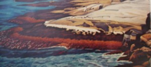
Peggy’s Cove, Nova Scotia.
A comparison of Stephenson’s 1948 painting (at left) of this granite slope in the intertidal zone at Peggy’s Cove with photos taken in the summer of 2001 (at right), shows a marked decline in the development of the 'barnacle belt' (the extension of barnacle growth above the highest seaweed). A closer look at the rock reveals some barnacles still living above the level of rockweed, but only in the extreme high flow areas (mostly in crevices). The visual effect of a white ‘belt’ has been lost. Interestingly, a comparison of these two pictures reveals today’s higher extent of the spray zone (buff colored rock with dark patches) which reflects the rise in sea level that has occurred over the last half century. The rise in sea level would result in an increase in time submerged for the higher positions in the intertidal habitat. This fact, alongside the fact of the downward contraction of the barnacle zone, implies that the minimum time submerged for the uppermost successful barnacle must be significantly higher today than it was a half century ago. The only plausible explanation for the receding of the barnacle population in an area like this one is that the abundance of appropriate food in the water must have declined to a considerable degree also. If the food available in seawater were a constant, the change expected in the barnacle belt would have been the opposite: an upward shift would have been seen to match the rise in sea level. The contrasting appearance of the two pictures most likely indicates the results of plankton dilution that has occurred during the 53 years between observations.
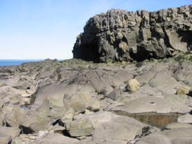
Stephenson described the composition and zonation of intertidal organisms at Peggy’s Cove in 1984 as being typical of the development that occurred on comparable rocky granite shorelines throughout this part of the world. Several nearby areas of similar, highly exposed rocky habitat were also surveyed for comparison in 2001. 'Barnacle belts' were essentially absent, in the sense that a growth of barnacles was not visible living at a higher point on the rocks than the point occupied by the highest rockweeds. Not even in the most highly wave-exposed areas. In a very few locations barnacles were visible above the rockweed, but in each case it was obvious that the rockweed itself was not living at the upper tidal limit for other rockweeds in the area…in all cases, in the ‘pristine’ areas surveyed, it appears that the upper vertical limit of barnacles has been lowered to a point below the upper limit of rockweeds.
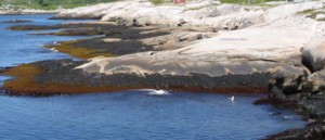
Above at right is an example of the characteristic appearance of the rocky exposed coastline in the area today. This photo was taken off Prospect, Nova Scotia, in July, 2001. Highly wave exposed, about 10 miles from Peggy's Cove, no trace of a 'barnacle belt' is visible there.
The Stephensons commented that "The highest subzone seen at Peggy Cove, dominated by barnacles, tends to occur on any shore in the region which is sufficiently exposed to wave action and where barnacles are common enough to characterize a zone at all." (Stephenson and Stephenson, 1954b)
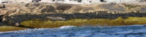
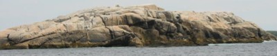
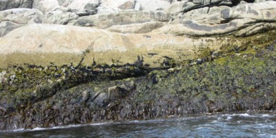
Less than 5 miles northeast of Peggy‘s Cove is White Island which, in the view shown here, is completely exposed to the pounding of the waves from the open Atlantic ocean. This rock ‘should’ therefore provide a classic demonstration of a high, well developed barnacle belt. Barnacles do live on White Island, although the area where they now live in greatest quantity is a lower positioned belt wherein they compete with small blue mussels. A heavy belt of barnacles, however, is visible at one point on the seaward side of the island. Here barnacles form a distinct line at the upper edge of a dense 'belt'. The line is clearly drawn in this case to delineate the boundary above which most barnacles will starve. Small rockweeds still exist at points significantly higher in the intertidal zone than do these barnacles. Not white, but beige, the position of this 'barnacle belt' demonstrates the upper limit of what this area of ocean is now able to ‘produce’ in successful barnacles. ‘Production’ appears to have been lowered significantly.
Photo at right clearly shows that the 'belt' consists of a dense growth of barnacles,
and the difference between the upper vertical limit of the barnacles and that of the rockweed.
White Island has an exceptionally high spray zone on its seaward side. Named over a century ago...was this rock perhaps called 'White' Island at that time due to the existence of an exceptional barnacle population that undoubtedly once lived there?
So, in conclusion, from these recent photographs, it is evident that shorelines in the area of Halifax County surrounding Peggy’s Cove also now consistently lack the ‘predictable’ or ‘normal’ development of barnacles in the upper limit of their natural habitat. The barnacle belt in this area is now mostly ‘conspicuous’ by its absence.
Meteghan
The Stephensons visited Meteghan, near the Nova Scotian side of the mouth of the Bay of Fundy. Although no photographs or paintings of the Meteghan shoreline are included in their texts, they described their findings:
"The shore of Meteghan, Nova Scotia, offers an example of conditions intermediate between those of the shores of Peggy Cove and Hall Harbour. The Meteghan shore is not truly oceanic, but is exposed to a large body of water (the Bay of Fundy, which is more than 70 miles across at that point, and gives onto the open Atlantic a short distance southwestward) and is, therefore, subject to considerable wave action. It has a steeply cliffed coast of shale like rock, and the strata are commonly tilted up on edge. The zone of particular interest is the midlittoral--the supralittoral and the infralittoral fringes have the usual characteristic littorinids and laminarians, respectively. The midlittoral zone at Meteghan has the same essential features that it has at Peggy Cove, but with some important modifications. Barnacles are more abundant here, and are crowded into a distinct belt in the upper part. There are the usual plants of Fucus vesiculosis, F. edentates, and Ascophyllum nodosum, which show the customary reactions to degrees of exposure, and in sheltered places can suppress barnacles altogether; they extend so freely downwards into the Chondrus zone that this zone is often indistinct…"(Stephenson and Stephenson, 1972)
At right: photo taken at Meteghan, late August, 2001.
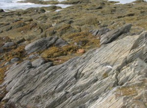
Without an older picture for comparison it is impossible to be certain that my photographs of this section of the Meteghan coastline (above) show the exact same one described by Stephenson. A very long section of the Meteghan coastline is composed of a rocky beach, but near the southwest limit of the village I found this rock formation with "the strata tilted up on edge" although no sign of "barnacles crowded into a distinct belt in the upper part." As Stephenson observed, this area is exposed to the 70 mile wide Bay of Fundy, but not actually to the open Atlantic ocean.
Stephenson seems to indicate that the occurrence of a well-developed barnacle belt coinciding with a lot of Ascophyllum nodosum is the thing that he finds unusual at Meteghan. The high, well developed barnacle belt he’d previously associated with extreme wave exposure…but Ascophyllum nodosum is not. Ascophyllum nodosum is a larger brown seaweed that develops much better in somewhat more sheltered locations and is predictably absent from the most heavily exposed rocky coasts. This area at Meteghan probably qualifies as ‘moderately exposed’ rather than ‘highly exposed,’ yet Stephenson seems to have seen what appeared to him as an unusually well developed barnacle belt, considering the degree of wave exposure.
The articles written by the Stephensons in 1954 included more detail about the distribution and appearance of barnacles at Meteghan:
"On rocks of average exposure there is a distinct upper subzone in which barnacles are dominant and Fucoids scanty (though extending sparsely as high up as the barnacles), above a broader subzone in which the Fucoids become more conspicuous than the barnacles. (In sheltered areas the Fucoid growth becomes denser at the higher levels, thus obliterating any distinct barnacle subzone, and ends abruptly.)" (Stephenson and Stephenson, 1954a)
In discussing the appearance of shorelines affected by varying degrees of ice scour, in a later article, Meteghan was described as an example of one where essentially no ice damage occurs:
"The barnacle population, however, was particularly interesting. It was perhaps richer than that seen anywhere else in the region. The barnacles were commonly very crowded, so as to form a thick hummocky layer on the rock, and consequently many of them assumed a weak, elongate form such as is often produced by crowding. There were so many grades of size that a number of spattings must have been represented (some very recent) at fairly close intervals. A high proportion were not so large that they could not be of that season’s growth; yet they had not the appearance of a population which had been largely swept away the previous winter…Large, old specimens freely colonized surfaces which would be vulnerable to ice action, as well as those less exposed to it." (Stephenson and Stephenson, 1954b)
The image of barnacles suggested by this text bears no resemblance whatsoever to the upper edge of the midlittoral zone as observed at Meteghan in 2001. There are no barnacles, and only sparse growth of fucus specimens form the upper border of the intertidal zone there today. The fucus is clearly not "obliterating any distinct barnacle subzone."
In 2001, the barnacle belt at Meteghan was simply absent.
Hall’s Harbour
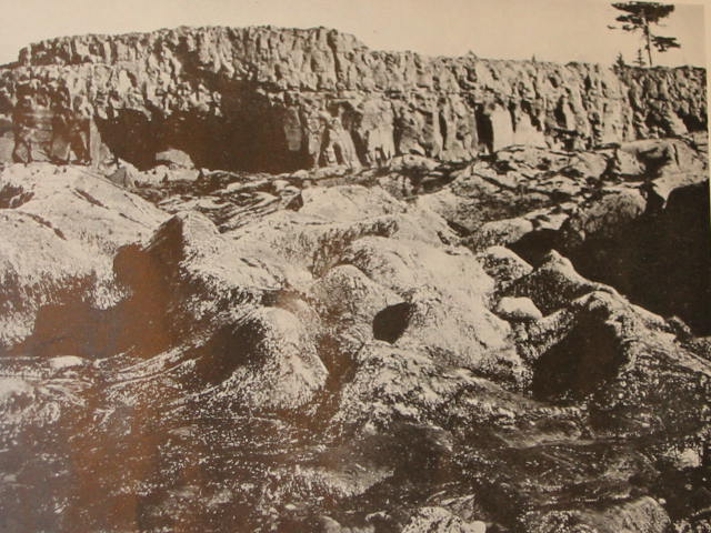
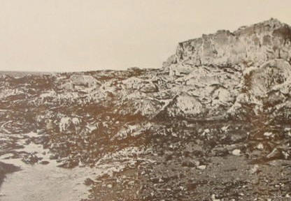
The Stephensons visited Hall’s Harbour, Nova Scotia, in August, 1948. Their description of the intertidal zone in an excerpt (and photo below at right) taken from their text:
"The area is a small harbour on the Minas Channel; a little to its northeast is a headland of hard grey basalt. From its foot, a massive rocky reef slopes unevenly to low-water level. This reef has irregular platforms studded with large and small boulders, and drops off precipitously, in some places, near sea level. The higher rocks are angular in shape and contrast with the rounded contours of the lower ones, which are worn by the friction of pebbles and ice. This coast is not oceanic nor is it exposed to as much open water as Meteghan is, but it does have 60 miles of open water to westward, and is subject to considerable wave action and to strong currents." (Stephenson and Stephenson, 1972)
The Stephensons illustrated their assessment of Hall’s Harbour with black and white photographs.
The caption below their photo reproduced at right reads "A view of the headland at Hall Harbour, Bay of Fundy, on August 20, 1948, at low water of a lesser spring tide. The angular shapes of the higher rocks contrast with the rounded shapes of the lower ones, which have been worn by pebbles and ice. The smooth rocks are thickly powdered with barnacles; on their lower parts is a dense, dark growth of Porphyra and other algae."
(Click on photo to see higher resolution view.)
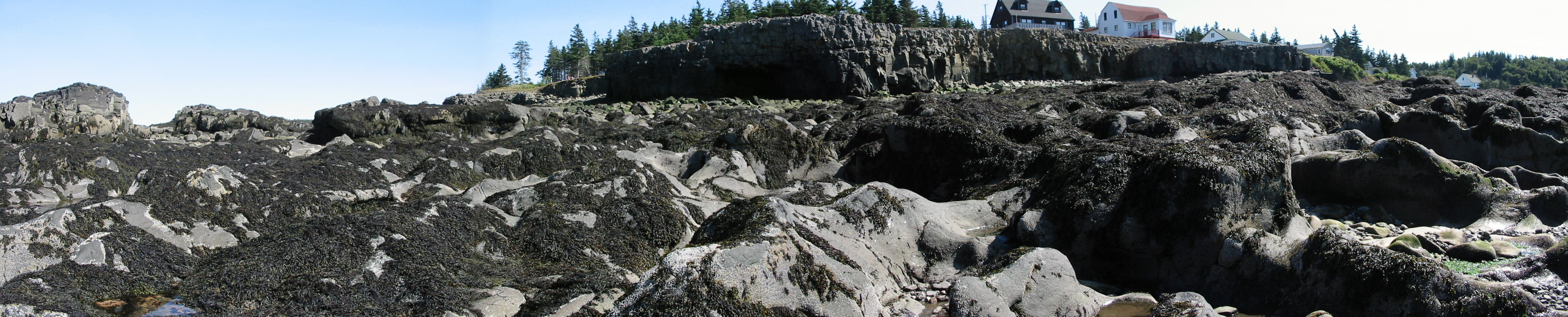
The Stephensons’ text elaborates on the characteristics of the intertidal life that they found at Hall’s Harbour in 1948. Following is a longer excerpt giving their complete description, included here for comparison with this photograph taken in late August, 2001.
(Click on the photo to see a large, high resolution
panoramic view of the area - file 1273KB)
"The Supralittoral Fringe.
This is a well-marked and extensive belt, inhabited by immense numbers of Littorina saxatilis. These snails, many of which are very large, extend plentifully through the midlittoral and are common to within a few feet of low water. The black zone is difficult to discern, as the basalt itself contains black patches, but there is a wide, ill-defined blackening, produced in part by impoverished plants of
Hildenbrandia prototypes.
The Midlittoral Zone.
This zone has a vertical depth of 30 feet. There is an enormous development of Balanus balanoides, sometimes reaching down to low-water level. Acmaea testudinalis is common, and Littorina littorea, L. obtusata and Thais lapillus are all abundant and normal in their distribution. Mytilus edulis is uncommon. Fucoids are abundant: Fucus vesiculosus and Ascophyllum nodosum extend over a wide range, and the latter, which may be over 2 feet long, is commonly overgrown by olysiphonia lanosa. Another notable alga is Porphyra umbilicalis, which exists in two forms: a handsome dark purple plant that occurs mainly from low water upwards, and a shorter brownish one that is plentiful from the upper midlittoral to high levels in the supralittoral fringe. The overlapping of these two forms in the middle of the shore indicates the position of the upper and lower parts of the midlittoral zone. Numerous other species together make a very substantial cover of seaweeds, but Chondrus crispus, though present in pools, occurs nowhere in quantities sufficient to constitute a subzone." (end of excerpt)
The barnacle cover at this location was described by the Stephensons as very "dense" although a very large proportion appeared to be juveniles:
"An enormous development of Balanus balanoides characterizes the zone, and these barnacles often form dense sheets. They show an unusual feature in that they continue densely, on some rocks, down to the level of low water and at least a little below this." (Stephenson and Stephenson, 1954a)
The Stephensons’ photographs do not show the upper limit of the barnacles at Hall’s Harbour accurately enough to identify how closely they may have approached the base of the cliff. However, a diagram included in one of their articles (1954a) indicates that barnacles "in quantity" began about 50 feet away from the base of the cliff. The impression received in 2001 is that barnacles are sparsely and irregularly dispersed throughout the lower midlittoral and gradually diminish to zero towards the upper part of the region. No upper 'border' effect was noticeable in the pattern of barnacles. The zone which lacked barnacles "in quantity" extended well beyond 50 feet from the base of the cliff.
At right, another of Stephenson's photos taken at Hall Harbour in 1948 (reproduced from Stephenson and Stephenson, 1954a).
(Hold mouse over photo to see the same area photographed in 2001.) Besides the dramatic decrease in the number of barnacles, remarkable differences are in the quantities of algae - rockweeds are much more abundant, and the lower growth of the purple Porphyra is far less than that described by the Stephensons.
A comparison of these two views seems to indicate that the upper limit of dense barnacle growth extended well up the larger, not completely intertidal, rock that is visible at the center background in the older picture. This comparison seems also to indicate a significant lowering of the upper limit of the range of barnacles at Hall’s Harbour.
The abundance and longevity of barnacles and intertidal seaweed can be affected by ice.
The Stephensons also made a note regarding ice scour inside the Bay of Fundy:
"At Hall’s Harbour, Nova Scotia, on the Bay of Fundy, there is usually some ice in February, but it is gone before April. It occurs as pieces of various sizes, including thick cakes that pile up on the shore, moving and eddying about. This ice can exert great pressure, and can damage or sweep away the large fish traps used locally, foundation boulders and all. The action of ice is combined with the scouring of stones and boulders, and it is difficult to determine which has the more harmful effect. Possibly, the moving stones and boulders are more destructive than the ice in this area. Cliffs and the hard basaltic rocks of higher zones form angular profiles; but lower down, the rocks are much smoothed and rounded, giving the appearance of great elephant’s feet. Barnacles were so plentiful that ice action was not immediately suspected, but close examination revealed that nearly all the large species likely to have survived the winter were in crevices and under overhangs, and that those on open rock were almost all from the current year’s settlement. The best Fucus and Ascophyllum showed the same restriction to protected positions. Places further south in the Bay of Fundy showed that ice is not a regular or extreme hazard to intertidal life there." (Stephenson and Stephenson, 1972)
"The barnacle population was at first sight deceptive. The barnacles were so abundant, clothing the open rock as well as the crevices so densely, that ice action was not at once suspected. On closer examination, however, it became evident that practically all the larger barnacles, which were likely to have survived a winter, were in crevices or other protected situations, whereas the sheets of them on open rock consisted almost entirely of the current year’s spat, with a marked difference in size between the generations. This suggested that ice could sweep away all the open-rock barnacles, but that a population such as we saw could easily be restored the next spring." (Stephenson and Stephenson, 1954b)
Incredible…by comparison to the remnant barnacle population observed in this exact location 53 years later…
Note: in Hall’s Harbour 2001, there appears to be a heavier growth of rockweed and a far lighter covering of barnacles than what was recorded by Stephenson in 1948. If the lack of barnacles was related to either extreme ice scour or scouring by loose rocks, a corresponding degree of damage, at least, should have been inflicted on the rockweed. Today’s relatively heavy rockweed growth implies that ice scour and pebble scour are less than they were 53 years ago, if indeed there is any difference. But, according to the notes from 1948, even heavy ice scour appeared unable to put a dent in the dense barnacle population that once covered these rocks at Hall’s Harbour.
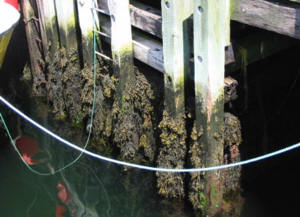
Many sources describe growth of barnacles and mussels on wharf pilings as if it is a standard occurrence. Not discussed in the Stephensons’ texts, but very commonly described in other marine biology sources, from which one might get the impression that growth of barnacles and mussels is simply a natural result of fixing a wooden pole vertically in the intertidal zone. That may or may not once have been true, but it certainly is not the case today. The development of barnacle and mussel growth on the undersides of wharves is very much affected by the location of the wharf today…and the key deciding factor appears to be the concentration of plankton in the water.
Wharves in little rural coves that open to the Atlantic ocean tend not to carry barnacles and mussels today as they did in the past. This observation may qualify only as ‘anecdotal’ but I am certain from my memory that the wharves inside East Dover had an abundance of mussels and barnacles attached to all underwater parts 30 - 40 years ago. I distinctly remember a blanket of blue mussels living below this ‘government wharf’ (pictured at right) - and today there are NO mussels there…zero! And there are only a very few barnacles. Looking at the barnacle- and mussel-encrusted wharf pilings in Halifax Harbour today brings back memories of wharves that I remember seeing as a child - and they could only have been the rural wharves; I never fished or swam in or around Halifax Harbour. The water surrounding the wharves in the fishing villages would once have been significantly nutrient-enhanced, perhaps, due to the fact that at that time they were very actively used fishing wharves. Large amounts of fish-offal were discarded into the water in the immediate area of these wharves on a regular basis in those years. The ever-present pile of decomposing fish flesh and bones that covered the bottom may well have played a role in supporting the large population of crustaceans that once thrived there on the underwater surfaces of the wharves. Of course, the open ocean water itself was also much more capable of supporting barnacle and mussel growth in years past, and this may have been another important factor.
6. THE ROLE PLAYED BY NUTRIENT AVAILABILITY IN THE DISTRIBUTION OF BARNACLES
A few significant variables appear to impact on the feeding success of barnacles. One undeniably important one is the concentration of nutrients (plankton) in the water. (Note: plankton = nutrients. The word "nutrients" seems to be used most often in marine science writing to denote only dissolved inorganic nutrients. But the true meaning of the word is naturally much wider than that, and from the point of view of this author - and the barnacles…plankton = nutrients.) For the barnacle, useful habitat must have a winning combination of plankton/nutrient concentration and degree of water movement. Casting a net into moving water greatly increases the chances of a reasonable catch. Lower concentrations of food are acceptable if water movement is sufficiently fast. If the concentration of food is high enough, however, much lesser degrees of water motion will still provide sufficient food to support the barnacle. This is well illustrated in the distribution pattern of barnacles in the past, and also in the pattern evident today.
Another short excerpt from the Stephensons’ descriptions of the typical Nova Scotian rocky intertidal zone:
"Below this is a zone where the granite has a buff tone, which extends from about the level to which waves wash in moderate weather (well above actual sea level at high water) down to the upper limit of the occurrence of either barnacles or Fucus in quantity…All of the barnacles appear to be Balanus balanoides. In some places, there is a neat belt of them above the Fucus, but it varies in extent in different localities. The barnacles extend freely into the Fucus zone, more plentifully into its upper parts, but may be absent altogether in areas where the weed growth is dense…" (Stephenson and Stephenson, 1972)
The Stephensons' assessment was that "either barnacles orFucus in quantity occupy the upper edge of the midlittoral zone." Therefore it was never observed that ‘barnacle belts’ always occurred at the upper limit of the midlittoral zone. Stephenson explains that the degree of exposure plays a clear role here, but doesn’t seem to relate it specifically to a difference in feeding opportunity for barnacles. They describe what they saw as a clear pattern of increased development of 'barnacle belts' corresponding to increasing degrees of wave exposure. And they seemed surprised to discover the distinct and well developed barnacle belt in less-exposed Meteghan. The Stephensons do not elaborate in detail (beyond wave exposure) on which factors tip the balance between the "either/or" - but their own observations support the conclusion that barnacle belts develop better when nutrient levels are higher.
Stephenson’s painting done at Peggy’s Cove in 1948 illustrates both sides of his statement that "either barnacles or fucus in quantity occupy the upper edge of the midlittoral zone," since the rocky spur in the foreground carries a definite white barnacle belt but the similar spurs in the background do not. On those rocks Fucus occupies the highest position. Undoubtedly that was accurate, since he was a meticulous observer and the background rocky spurs are not so far back that a similar barnacle belt would not have been visible had it been there.
The reason for the appearance of a barnacle belt on the rock in the foreground of the Peggy’s Cove pictures, but not on the rocks in the background, can be deduced from a look at the surrounding topography. The granite spur in the foreground of Stephenson’s painting actually forms one side of a small cove that converges in toward the base of a large, relatively shallow ‘funnel’ formation in the cliff. This natural rock formation greatly amplifies wave action in this immediate area when the tide is higher. Therefore, the greater water movement adjacent to this particular rock, but not those in the background, accounts for the (former) development of a distinct barnacle belt in that area. The effects of enhanced flow and relatively greater nutrient availability to organisms living on that particular rock is still visible today - in the relatively deeper pigmentation of Chondrus crispus that still grows there (for a detailed description and more pictures, see the
seaweed article included on this website).
The appearance of a well developed barnacle belt at Meteghan, Bay of Fundy, in a less-exposed area than those usually associated with this amount of growth, was probably due to the uncommonly highly productive nature of the Bay of Fundy/Gulf of Maine ecosystem. This area of the ocean has the highest tides in the world, therefore year round top-to-bottom mixing of the water occurs, and a phenomenal amount of marine life had accumulated there over eons. The Bay of Fundy may have been the single most ‘productive’ piece of coastal seawater anywhere, with richer water than the average coastal Atlantic ocean. Fish also grew fatter and more quickly in this part of the Atlantic ocean than in other areas. The extremely high level of marine productivity that once existed in the Bay of Fundy also necessarily included an exceptionally high abundance of plankton…hence the formation of the barnacle belt at not-so-heavily-exposed sites like that observed by the Stephensons at Meteghan in 1948.
The "enormous" development of barnacles observed by the Stephensons at Hall’s Harbour was undoubtedly also due in part to the exceptionally rich nature of the seawater in the Bay of Fundy at that time.
And the well-developed barnacle population that the Stephensons observed inside Halifax Harbour in 1948, in an area with "reduced wave action," was possibly stimulated by enhanced plankton growth in the Harbour even at that time due to human sewage input. From their notes:
"Halifax Harbour is an area with a biota intermediate between a fully developed open-coast population and one in a deep inlet. Our work in the area was carried out in August of 1948; since that time, the shore on which we worked has been obliterated by naval operations. It had reduced wave action, but was not a protected deep-set inlet…the midlittoral had large quantities of mussels and barnacles, including, in many places, unusually large individuals of Balanus balanoides…"
In 1948 they also surveyed a cleaner deep-set inlet in St. Margaret’s Bay, at Mason’s Cove, and commented: "Most noticeable, by comparison with the midlittoral zone at Peggy Cove, is the absence here of barnacles…"
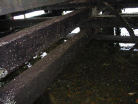
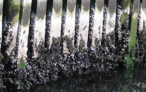
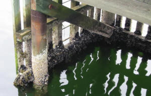
In contrast, travelling far inside Halifax Harbour today, to the innermost margin of sheltered Bedford Basin, one can see very well developed barnacle and mussel growth on intertidal structures there. At right, below, is a recent photo taken of a small wharf inside Bedford Basin. This type of heavy growth of barnacles, once normally ‘expected’ to form only under conditions of heavy ocean wave exposure, and not inside sheltered inlets, has formed here today due to conditions of heavy plankton growth secondary to a high level of sewage pollution.
At left, below, is picture of a another wharf midway inside Halifax harbour. There is an easily visible, well developed growth of barnacles there. Polluted Halifax harbour was the only place seen in this year’s survey where the barnacle belt was so pronounced and "conspicuous" that it just might be "visible for miles." The formation of the barnacle belt is no longer the natural result of coastal exposure to ocean wave action since nutrient content of the sea has been so drastically reduced. Now, what was noted 50 years ago to be "one of the most distinct landmarks on the shore," and actually signalled a relatively healthy and robust marine ecosystem at that time, the "conspicuous" barnacle belt …only indicates a waterway overloaded with human sewage. The oft-repeated claim that ‘pollution’ is the prime cause of the disappearance of marine life…apparently ‘holds no water’ in the case of the missing barnacles… nutrient ‘pollution’ is clearly the thing that now sustains their best growth.
Photo at left, above, shows the current barnacle and mussel growth on a wharf midway inside Halifax harbour. At right is a wharf at the far inside reach of this harbour, at sheltered Bedford Basin. By comparison to the preceding photos of rocky exposed locations, these two areas experience very reduced wave action...yet they display the most developed 'barnacle belts' observed in this survey.
Food availability is simply the single most critical factor that determines the distribution of barnacles.
Which factors are most important in determining the dominance of one organism over the other? And how might an overall decline in nutrient content of seawater affect this balance?
The upper limit for rockweed growth is generally agreed to be determined by dessication tolerance - and this fact often results in a clear horizontal line being formed along the coast by the upper specimens, which usually are fucus spiralis in Nova Scotia. Barnacles can tolerate drying significantly better than can the seaweeds, therefore in conditions where the food supply is rich enough to subsist on a short daily immersion time, barnacles will occupy a higher position in the intertidal zone than will fucus spiralis.
Other factors come into play in the competition between barnacles and rockweed. The angle of the substrate has an effect on the outcome of competition. Apparently the sweeping motion of established rockweeds discourages the successful attachment of young barnacles. However, on overhanging rock faces or vertical surfaces that are exposed at low tide, rockweed appears to have relatively lower success, possibly partly due to the strain of supporting all of its own weight, as well as the "sweeping" effect of the algae on the rocks probably becoming less intense at steeper angles. Settlement of new young rockweeds at the steeper angles may also be more difficult.
On vertical wharf pilings the competitive balance between rockweed and barnacles has been frequently observed to favor the barnacles. This is well illustrated in the above photographs from Halifax Harbour, a polluted body of water that does, however, support the simultaneous growth of fucus species on rocky habitat near to these wharves.
In the cleaner waters a short distance along the coast from Halifax Harbour, however, the dominance of barnacles (and mussels) on wharf pilings is no longer evident. In fact, wharves that once supported the ‘normal’ community of barnacles and mussels now appear to support little more than an assortment of algae species. An example is the previously mentioned 'government' wharf in East Dover which, in this author’s youth, supported a much greater population of barnacles, mussels and their predators (dog whelks and starfish). Most clearly I remember the blanket of blue mussels that lived under this wharf, of which not even a remnant population is visible today. A look at one of the outer pilings shows a small area still encrusted with barnacles. But rockweed specimens are visible hanging on at least a foot higher up the piling than the highest barnacle. More characteristic of this wharf today is the view shown in the photo at right. Rockweeds are more successful today on the wharf in the clean (…possibly too clean?) water of East Dover than in the heavy nutrient-enriched water in Halifax Harbour.
The change that seems to have occurred (in ‘clean’ water) is that the upper limit of barnacle growth has receded to a lower level than the upper limit of seaweed growth. This appears to be true now regardless of the degree of wave exposure, and is clearly at odds with earlier records of this same type of coastal habitat.
How could the rockweed maintain itself longer at the higher positions/shorter immersion times than the barnacle? It most likely is a reflection of nutrient (specifically protein/nitrogen) requirements. Barnacles depend on plankton for food, which means that their upwards distribution is a reflection of the availability of this specific food source. So the height of the barnacle zone probably accurately reflects the abundance of the total plankton mix -- more specifically it reflects the nutritional value of the existing plankton mix. But rockweed absorbs dissolved nutrients directly from the water…therefore it exists at a much lower trophic level than do organisms like barnacles. As the entire marine ecosystem ‘downshifts,’ this distinction allows rockweed to persist for a longer time than barnacles.
A look at the makeup of plankton versus seaweed also provides a clue. An excerpt from the book "Seaweed Ecology and Physiology" by Lobban and Harrison (1994, p 203) (bold type mine):
"Extensive analysis of the chemical composition of marine plankton has revealed that the ratio relating carbon, nitrogen, and phosphorus is 106 : 16 : 1 (by atoms) (i.e. C : N = 7 : 1 and N : P = 16 : 1). This is commonly referred to as the Redfield ratio. Decomposition of this organic matter occurs according to the same ratio. However, Atkinson and Smith (1983) have recently shown that benthic marine macroalgae and seagrasses are much more depleted in phosphorus and less depleted in nitrogen, relative to carbon, than are phytoplankton. The median ratio C : N : P for seaweeds is about 550 : 30 : 1 (I.e., C : N = 18 : 1 and N : P = 30 : 1). An important ramification of these observations is that the amounts of nutrients required to support a particular level of net production are much lower for macroalgae than for phytoplankton. In addition, seaweeds, on average, should be less prone to phosphorus limitation with their N : P ratio of 30 : 1 than are phytoplankton, with an N : P ratio of 16 : 1. The high C : N : P ratios in seaweeds are thought to be due to their large amounts of structural and storage carbon, which vary taxonomically. Niell (1976) found higher C : N ratios in the Phaeophyceae than in either the Chlorophyceae or Rhodophyceae. The average carbohydrate and protein contents of seaweeds have been estimated at about 80% and 15%, respectively, of the ash-free dry weight (Atkinson and Smith 1983). In contrast, the average carbohydrate and protein contents of phytoplankton are 35% and 50%, respectively (Parsons et al. 1977)." (Lobban and Harrison, 1994)
Therefore the protein requirement to ‘build’ phytoplankton is significantly higher than that needed to ‘build’ seaweed. Zooplankton depend entirely upon phytoplankton for food. Undoubtedly, zooplankton as a group also have a protein content that is significantly higher than that of seaweeds, and maybe even higher than that of phytoplankton…fish being typically a more concentrated protein source than vegetables.
The ability of macroalgae to store nutrients and to thrive in poorer water than can plankton and plankton feeders, plus the lack of competition for the space today - these factors seem to explain today’s heavier growth of rockweed on wharves once dominated by attached plankton feeders. This reversal of dominance from barnacles to rockweeds can also sometimes be seen on rocky coastline such as that at Hall's Harbour, discussed above.
(Looking to the tropics…might this particular insight also help to explain the recent phenomenon of macroalgal overgrowth and displacement of corals on many ‘pristine’ coral reefs? Corals have many unique features, but they share a few important basics with barnacles; both are sessile suspension feeders, dependent for food upon zooplankton delivered by the seawater. Maybe this is a key to gaining a deeper understanding of the
coral story as well.)
Seaweeds may well thrive in less rich water than that which is required to support an abundance of plankton and plankton feeders, yet seaweeds today in Atlantic Canada are showing worrisome signs of nutrient shortage themselves (see
seaweed article on this website).
Compared to 50 years ago, in coastal rural Nova Scotia today 'the barnacle belt isn’t wearing any barnacles!' Literally true, this is easily observed in the few locations where careful records were made 53 years ago. The significant decline of barnacles is a simple observation, yet a valid one, which provides another piece of evidence of the insidious (and largely unsuspected) trend of overall marine biomass depletion that has been occurring in the open ocean ecosystem. Do today’s scientific estimates of marine productivity account for the current relative lack of 'barnacle productivity?' How close are our scientific assessments to the truth? The decline in 'barnacle productivity' is one of many missing pieces of information that must be considered by anyone attempting to make an accurate assessment of the health, vitality and 'productive capacity' of the ocean. Are humans most capable of truly measuring such a thing…or perhaps are the lowly barnacles better equipped to factor in all of the variables and demonstrate the truth of the matter?
Nutrient depletion of the open ocean…a terrible realization, a terrible prospect…might this be the reason why this particular ‘hypothesis’ is never proposed, because it’s just too awful to contemplate?
But science must be objective; it is utterly irrelevant whether or not we ‘like’ a particular theory, the important thing is only whether or not the theory explains the observations…
P.S. During the years of their study the Stephensons visited rocky shores on many other parts of the globe. Their 1972 book "Life Between Tidemarks on Rocky Shores" contains careful descriptions - and a few fairly good photographs - of barnacle belts that existed at identifiable locations in other parts of Canada and in other countries. It would be very interesting to revisit those bits of rocky coastline today and document the extent of barnacle growth there now for comparison. The book contains reasonable black and white photographs that record the position of barnacle belts, in the 1940s, at the following locations:
Winneba (Ghana)
Brandon Island (inside Departure Bay on Vancouver Island, Canada)
Victoria (headland near harbour entrance, also on Vancouver Island, Canada)
Iquique (Chile)
Point Sinclair (South Australia)
Wilson’s Promontory (Victoria, Australia)
Port Arthur (Tasmania - this one shows a belt of Galeolaria rather than barnacles, which might be similarly useful)
Sydney (Australia)
Newcastle (New South Wales, Australia - also shows Galeolaria)
Great Barrier Island (North Island, New Zealand)
Sound of Jura (western Scotland)
Kerry (southwest Ireland)
Sutherland (northwest Scotland)
Acknowledgements
My thanks are due to the people that assisted with the barnacle survey. Providers of boat rides and physical and moral support were Kathy Bell, Michael LeBlanc, Nacho Chavarria Fuentes and Karen Lewis.
Also greatly appreciated was the support and encouragement for this research offered by the late Dr. Don E. McAllister.
Kennish, Michael J. 1998. Pollution Impacts on Marine Biotic Communities. CRC Press.
Lobban, Christopher S. and Paul J. Harrison. 1994. Seaweed Ecology and Physiology. Cambridge University Press.
Olson, Theodore A. and Frederick J. Burgess (eds). 1967. Pollution and Marine Ecology. Interscience Publishers.
Soule, Dorothy F. and G. S. Kleppel (eds). 1988. Marine Organisms as Indicators. Springer-Verlag.
Stephenson, T. A. and Anne Stephenson, 1954. Life between tide-marks in North America, IIIA. Nova Scotia and Prince Edward Island: description of the region. J. Ecol. 42: 14-45.
Stephenson, T. A. and Anne Stephenson, 1954. Life between tide-marks in North America, IIIB. Nova Scotia and Prince Edward Island: the geographical features of the region. J. Ecol. 42: 46-70.
Stephenson, T. A. and Anne Stephenson, 1972. Life Between Tidemarks on Rocky Shores. W. H. Freeman and Company.
Yonge, C. M. 1949. The Sea Shore. Great Britain: Collins St. James's Place, London.
 Stephenson described the composition and zonation of intertidal organisms at Peggy’s Cove in 1984 as being typical of the development that occurred on comparable rocky granite shorelines throughout this part of the world. Several nearby areas of similar, highly exposed rocky habitat were also surveyed for comparison in 2001. 'Barnacle belts' were essentially absent, in the sense that a growth of barnacles was not visible living at a higher point on the rocks than the point occupied by the highest rockweeds. Not even in the most highly wave-exposed areas. In a very few locations barnacles were visible above the rockweed, but in each case it was obvious that the rockweed itself was not living at the upper tidal limit for other rockweeds in the area…in all cases, in the ‘pristine’ areas surveyed, it appears that the upper vertical limit of barnacles has been lowered to a point below the upper limit of rockweeds.
Above at right is an example of the characteristic appearance of the rocky exposed coastline in the area today. This photo was taken off Prospect, Nova Scotia, in July, 2001. Highly wave exposed, about 10 miles from Peggy's Cove, no trace of a 'barnacle belt' is visible there.
Stephenson described the composition and zonation of intertidal organisms at Peggy’s Cove in 1984 as being typical of the development that occurred on comparable rocky granite shorelines throughout this part of the world. Several nearby areas of similar, highly exposed rocky habitat were also surveyed for comparison in 2001. 'Barnacle belts' were essentially absent, in the sense that a growth of barnacles was not visible living at a higher point on the rocks than the point occupied by the highest rockweeds. Not even in the most highly wave-exposed areas. In a very few locations barnacles were visible above the rockweed, but in each case it was obvious that the rockweed itself was not living at the upper tidal limit for other rockweeds in the area…in all cases, in the ‘pristine’ areas surveyed, it appears that the upper vertical limit of barnacles has been lowered to a point below the upper limit of rockweeds.
Above at right is an example of the characteristic appearance of the rocky exposed coastline in the area today. This photo was taken off Prospect, Nova Scotia, in July, 2001. Highly wave exposed, about 10 miles from Peggy's Cove, no trace of a 'barnacle belt' is visible there.
 Wharves in little rural coves that open to the Atlantic ocean tend not to carry barnacles and mussels today as they did in the past. This observation may qualify only as ‘anecdotal’ but I am certain from my memory that the wharves inside East Dover had an abundance of mussels and barnacles attached to all underwater parts 30 - 40 years ago. I distinctly remember a blanket of blue mussels living below this ‘government wharf’ (pictured at right) - and today there are NO mussels there…zero! And there are only a very few barnacles. Looking at the barnacle- and mussel-encrusted wharf pilings in Halifax Harbour today brings back memories of wharves that I remember seeing as a child - and they could only have been the rural wharves; I never fished or swam in or around Halifax Harbour. The water surrounding the wharves in the fishing villages would once have been significantly nutrient-enhanced, perhaps, due to the fact that at that time they were very actively used fishing wharves. Large amounts of fish-offal were discarded into the water in the immediate area of these wharves on a regular basis in those years. The ever-present pile of decomposing fish flesh and bones that covered the bottom may well have played a role in supporting the large population of crustaceans that once thrived there on the underwater surfaces of the wharves. Of course, the open ocean water itself was also much more capable of supporting barnacle and mussel growth in years past, and this may have been another important factor.
 In the cleaner waters a short distance along the coast from Halifax Harbour, however, the dominance of barnacles (and mussels) on wharf pilings is no longer evident. In fact, wharves that once supported the ‘normal’ community of barnacles and mussels now appear to support little more than an assortment of algae species. An example is the previously mentioned 'government' wharf in East Dover which, in this author’s youth, supported a much greater population of barnacles, mussels and their predators (dog whelks and starfish). Most clearly I remember the blanket of blue mussels that lived under this wharf, of which not even a remnant population is visible today. A look at one of the outer pilings shows a small area still encrusted with barnacles. But rockweed specimens are visible hanging on at least a foot higher up the piling than the highest barnacle. More characteristic of this wharf today is the view shown in the photo at right. Rockweeds are more successful today on the wharf in the clean (…possibly too clean?) water of East Dover than in the heavy nutrient-enriched water in Halifax Harbour.